ELPC Press Release

$25,000 Summer MATCH on now!
DONATE
$25,000 Summer MATCH on now!
DONATEMay 01, 2020
In the spring of 2019, heavy floods damaged crops, homes, and infrastructure in communities across the Midwest. Water levels reached record highs in several places, affecting nearly 14 million people. After such floods, levees are supposed to receive extensive monitoring and maintenance, because they serve a vital role in defending riverfront communities from damage. Unfortunately, many communities remain at risk along the Mississippi River in Illinois, Iowa, and Missouri.
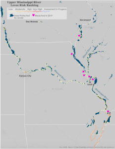
Upper Mississippi River Levee Risk Ranking Map (see report for full map)
In this report, ELPC gathered levee data from the United States Army Corps of Engineers (USACE) and identified the need for robust monitoring, reinforcement, and repairs. Many levees have not been assessed since 2016, including some in the “high-risk” and “moderate-risk” categories. Moreover, some low-risk levees failed in the 2019 floods, raising concerns about the strength of even “low-risk” levees.
Scientists have already recorded about a 9% increase in annual precipitation over the past few decades and anticipate heavy rain events to increase Midwestern flooding risk as global temperatures rise. Prudent decision makers should take climate resilience into account for long-term planning, prioritize which levees are repaired given limited federal and state funds, and shift towards green infrastructure.